- Copano, Texas
-
Copano, Texas or El Copano (Spanish) is a ghost town on the northwestern shore of Copano Bay in Refugio County. It is located 5 miles (8.0 km) north of present day Bayside, on Copano Point. The port, which holds the distinction as the first in South Texas,[1] was founded in the early 18th century by the Spanish, and named for the Copane Indians that resided in the area. Initially, it was used as a port by smugglers and pirates until 1785 when it was officially opened for use by the Spanish empire. The port was abandoned in the 1880s,[2] following the settlement of the area following the Texas Revolution. Ruins of the town-site can still be found, but are currently in danger of falling into Copano Bay.
Contents
History
Port usage
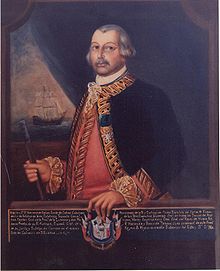 New Spain viceroy Bernardo de Galvez
After its founding, El Copano was a common port used by pirates and smugglers.[2] In 1785, it was officially opened by New Spain Viceroy Bernardo de Gálvez y Madrid, Count of Gálvez for entry into Texas. Around this time, a customhouse and freshwater tank were all that could be found on land, but the port was valued. General Juan Almonte described it as the deepest port on the Texas coast during an 1834 inspection for Antonio López de Santa Anna,[2] and it was described as the "safest" on the coast, due to its protection by Copano Reef.[2] Copano was also used by many Irish emigrants from 1828 to 1835, many of whom landed at the port during their trek from New York to the Irish colony of San Patricio. At least 200 of these settlers died of cholera upon arrival and were buried on Copano beach.[2]
During the Texas Revolution, the port was used by both the Mexican and Texian armies. General Martín Perfecto de Cos of Mexico, entered at Copano en route to the missions at San Antonio and Goliad in September 1835. It was fortified by the Texians the following month, and used to transport food and supplies until it was captured by Mexican General José de Urrea in March 1836. The Mexicans held on to the port until the end of the war, and used it to obtain reinforcements and send the injured and prisoners to Mexico. At the end of the war, several Mexican vessels, soldiers and supplies were taken by the "Horse Marines" led by Texian Major Isaac Burton and the Texas Rangers.[2]
Settlement
James Power and business partner James Hewetson were granted the land between the Lavaca River and the Nueces River as Empresarios in 1825, to create an Irish and Mexican settlement. However in 1828, the settlement was restricted to only include the area between the Guadalupe River and Lavaca. Although this restriction was reversed in 1829, land disputes with local citizens and hostilities between the Texians and Mexicans prevented any colonization attempts at Copano.[3]
After signing the Texas Declaration of Independence and winning Independence from Mexico, Power established a permanent settlement at Copano in 1836.[4] The house of Joseph E. Plummer is believed to be the first of nearly a dozen homes that had been constructed, using oyster shell concrete (shellcrete) obtained from Copano beach. Power was completing a two story house of his own at the site prior to his death in 1852.[5] A school was established as well as a post office, which was used until 1864. Three wharves were built on the bayfront to accommodate traders contributing to the prosperity of the settlement; their primary goods included cotton, hides, and tallow.[2]
Decline
During the American Civil War, Copano continued to flourish, unlike other blockaded Confederate ports, because of its location on a point, which allowed goods to be shipped without being noticed by the Union forces.[2] This came to an end in 1864, when a Union fleet anchored just off Copano, causing the settlers to leave for several days.[2] After several failed attempts to build railroads to Goliad and San Antonio, and trouble maintaining a supply of freshwater, most settlers relocated to Refugio.[2] The abandonment was complete by 1888[4] after a wave of destructive hurricanes.[1]
Remains
The ruins of Copano can be accessed from the shore of Bayside via watercraft. However, it is currently located on private property owned by the descendants of Empresarios. A historical marker was placed at the site in 1936, but was relocated 5 miles (8.0 km) south at Bayside Park, after nearly falling into Copano Bay during a 1978 storm.[6] An archeological survey by the Bayside Historical Society was completed in 2005,[1] and found a cistern along with ten shellcrete homes on the edge of a cliff off Copano Bay.[4] The study concluded that the ruins would soon fall into the bay, noting that the shoreline had receded 100 feet (30 m) since 1935. It is believed that the Plummer residence had already sank to the bottom of the bay.[4] Copano, Texas is currently named as one of state's most endangered historical sites.[7]
References
- ^ a b c "El Copano". The Bayside Historical Society. http://www.baysidehistoricalsociety.com/elcopano.html. Retrieved 29 June 2010.
- ^ a b c d e f g h i j Benowitz, June Melby. "Copano, Texas". Handbook of Texas Online. Texas State Historical Association. http://www.tshaonline.org/handbook/online/articles/CC/hvc74.html. Retrieved 29 June 2010.
- ^ Huson, Hobart (2001-2006). "Irish Power & Hewetson Colony". Sons of DeWitt Colony Texas. http://www.tamu.edu/ccbn/dewitt/irishpowhew1.htm. Retrieved 30 June 2010.
- ^ a b c d Wolff Jr., Henry (July 2, 2006). "El Copano is heading for a watery grave". The Victoria Advocate.
- ^ Huson, Hobart. "Copano". The TXGenWeb Project. http://www.rootsweb.ancestry.com/~txrefugi/Copano.htm. Retrieved 30 June 2010.
- ^ "Refugio County Historical Markers". Fort Tours. http://www.forttours.com/pages/hmrefugio.asp. Retrieved 30 June 2010.
- ^ "El Copano (Ghost Town)". Travel South Texas. Texmaps and Carson Map Company, Inc. 2010. http://www.stxmaps.com/go/el-copano-ghost-town.html. Retrieved 30 June 2010.
Further reading
- Huson, Hobart (1935). El Copano, the ancient port of Bexar and La Bahia. Refugio Timely Remarks.
- Huson, Hobert (1955). Refugio: A Comprehensive History of Refugio County from Aboriginal Times to 1953. Rooke Foundation.
Coordinates: 28°08′45″N 97°07′49″W / 28.145908°N 97.130406°W
Municipalities and communities of Refugio County, Texas County seat: Refugio City 
Towns Unincorporated
communityGhost towns Copano | St. Mary's of Aransas
Categories:- Geography of Refugio County, Texas
- Ghost towns in South Texas


Wikimedia Foundation. 2010.