- Church of St Mary, Moorlinch
-
Church of St Mary 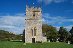
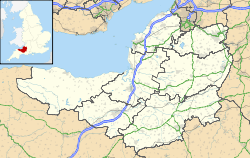
 Location within Somerset
General information Town or city Moorlinch Country England Coordinates 51°07′41″N 2°51′42″W / 51.1280°N 2.8616°W Completed 13th century The Church of St Mary in Moorlinch, Somerset, England dates from the 13th century and has been designated as a Grade I listed building.[1] The church sits on the southern flank of the Polden Hills.[2]
The earliest mention of a church at Moorlinch is a charter of King Ine in 725 and then in one of King Edgar in 971, although the authenticity of these documents has been challenged. In 1262 it was acquired by Glastonbury Abbey in 1262. The church includes a 14th century chancel, and a 12th century nave with a south porch. The font dates from the 12th century, while the pulpit is Jacobean,[3] but made from wood taken from earlier perpendicular panels. The organ dates from 1800 and was made by James Davis.[1]
The west tower contains six bells the oldest being the tenor which was cast in 1651 by Thomas Purdue of Closworth.[3]
The parish is part of the benefice of Middlezoy and Othery and Moorlinch with Stawell and Sutton Mallet, within the Glastonbury deanery.[4]
See also
- List of Grade I listed buildings in Sedgemoor
- List of towers in Somerset
References
- ^ a b "Church of St Mary". Images of England. http://www.imagesofengland.org.uk/details/default.aspx?id=269561. Retrieved 3 February 2008.
- ^ Corcos, Nick. "Churches as Pre-Historic Ritual Monuments: A Review and Phenomenological Perspective from Somerset". University of Sheffield. http://www.assemblage.group.shef.ac.uk/issue6/Corcos_web.html. Retrieved 30 October 2011.
- ^ a b Robert Dunning (Editor) (2004). "Moorlinch". A History of the County of Somerset: Volume 8: The Poldens and the Levels. Institute of Historical Research. http://www.british-history.ac.uk/report.aspx?compid=15112#s15. Retrieved 30 October 2011.
- ^ "The Blessed Virgin Mary, Moorlinch". Church of England. http://www.achurchnearyou.com/moorlinch-the-blessed-virgin-mary/. Retrieved 30 October 2011.
Categories:- Church of England churches in Somerset
- 13th-century architecture
- Grade I listed churches
- Grade I listed buildings in Somerset
- Sedgemoor


Wikimedia Foundation. 2010.