- Cerro San Luis Obispo
-
Cerro San Luis Obispo 
Cerro San Luis (left)Elevation 1,292 ft (394 m) NGVD 29[1] Translation Bishop Saint Louis Hill (Spanish) Location Location San Luis Obispo County, California, USA Range Santa Lucia Range Coordinates 35°16′58″N 120°40′50″W / 35.2827524°N 120.6804498°WCoordinates: 35°16′58″N 120°40′50″W / 35.2827524°N 120.6804498°W[2] Topo map San Luis Obispo Geology Type Volcanic plug Age of rock 20 million years Volcanic arc/belt Nine Sisters Cerro San Luis Obispo is a 1,292 feet (394 m) mountain in San Luis Obispo, California. It is part of the chain of peaks called the Nine Sisters, and is often referred to as San Luis Mountain, Mount San Luis, or Madonna Mountain. It is a popular spot for mountain biking and hiking, offering spectacular views and steep terrain. There is a wide dirt road traversing the mountain that leads to the peak. Right below the west side of the visible peak, there is a fairly large plateau with a large wooden stage on the east end. A large white "M" is present on the east face, which derives from the Mission School and not Madonna as most believe.
History
Some time around 1900, an American Civil War veteran, G. W. Chandler, lived on the mountain and planted lemons and oranges. The trees still overlook the city and are watered by two springs. The Lemon Grove Trail at the base of the mountain takes its name from these groves.[3]
Around 1958, a local business owner, Alex Madonna purchased a ranch on a portion of the slopes of Cerro San Luis Obispo, and constructed the now famous Madonna Inn at its base.[4] This is how the mountain also came to be called "Madonna Mountain".
Activities
There are several trails on the mountain that are good for hiking, mountain biking, and jogging. The primary trail head is at the end of Marsh Street which provides access to the Open Space and Lemon Grove Loop. A dirt road accessible from Lemon Grove Loop leads to the summit. There is a second road cut to the summit which has been abandoned and eroded to a narrow rocky path giving it the name "Rock Garden" and making it a popular decent for mountain bikers. There is also a trail that encircles the mountain about one third the way up.
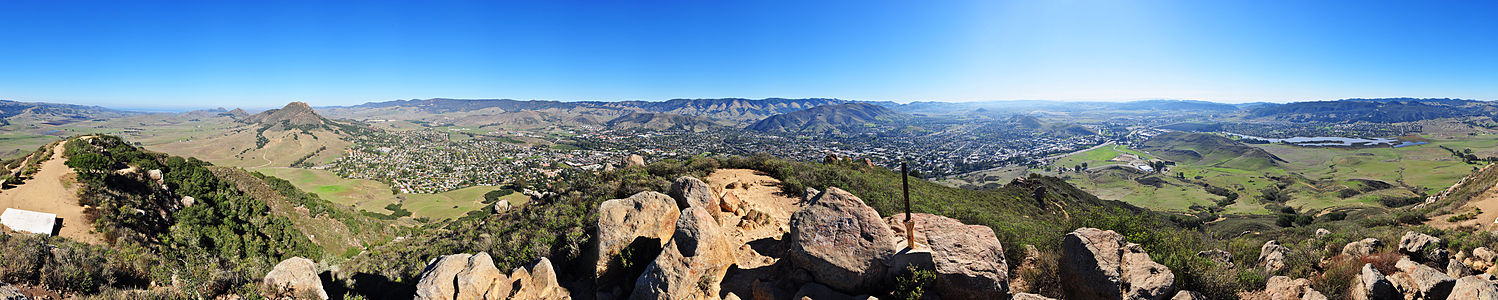 360° panorama from the summit of Cerro San Luis Obispo. On the left appears Bishop Peak. In the left-center lies the Cal Poly campus. Laguna Lake appears on the right. Photographed on an early November morning.
References
- ^ USGS. San Luis Obispo quadrangle, California (Map). 1:24000. 7.5 Minute Topographic. http://www.topoquest.com/map.php?lat=35.2827524&lon=-120.6804498&datum=nad83&zoom=4&size=l. Retrieved 2009-12-20.
- ^ "Cerro San Luis Obispo". Geographic Names Information System, U.S. Geological Survey. http://geonames.usgs.gov/pls/gnispublic/f?p=gnispq:3:::NO::P3_FID:255463. Retrieved 2009-12-20.
- ^ "Cerro San Luis". Eco SLO. http://www.ecoslo.org/programsprojects/naturalsanluis/hikes/cerro. Retrieved 2009-12-20.[dead link]
- ^ "The Nine Sisters of San Luis Obispo County". Santa Lucia Chapter, Sierra Club. http://santalucia.sierraclub.org/ninesis.html. Retrieved 2009-07-01.
Nine Sisters Bishop Peak · Black Hill · Cerro Cabrillo · Cerro Romauldo · Cerro San Luis Obispo · Chumash Peak · Hollister Peak · Islay Hill · Morro Rock
Categories:- Nine Sisters
- Mountains of San Luis Obispo County, California
- Mountain biking venues in the United States


Wikimedia Foundation. 2010.