- U.S. Route 97 in Oregon
-
"OR 4" redirects here. OR 4 may also refer to Oregon's 4th congressional district.
U.S. Route 97

Route information Maintained by Oregon DOT Existed: 1930s – present Major junctions South end:  US 97 at California state line
 OR 66 in Klamath Falls
 OR 140 in Klamath Falls
 OR 58 near Chemult
 US 20 in Bend
 OR 126 in Redmond
 US 26 in Madras
 US 197 near Shaniko

 I-84 / US 30 in Biggs Junction
North end:  US 97 at Washington state line
Highway system United States Numbered Highways
List • Bannered • Divided • ReplacedOregon highways
Routes • Highways←  US 95
US 95OR 99  →
→In the U.S. state of Oregon, U.S. Route 97 is a major north–south United States highway which runs through the state of Oregon (among other states). In Oregon, it runs from the Oregon-California border, south of Klamath Falls, to the Oregon-Washington border on the Columbia River, between Biggs Junction, Oregon and Maryhill, Washington. Other than the northernmost stretch (which is known as the Sherman Highway), US 97 (along with U.S. Route 197) is known as The Dalles-California Highway. In May 2009, Oregon Senate passed a bill to rename U.S. Route 97 as "World War II Veterans Historic Highway".
With the exception of Interstate 5, US 97 is the most important north–south highway corridor in the state. It serves two major population centers (Klamath Falls and Bend), and is the main corridor east of the Cascade Mountains. While much of the highway remains in two-lane undivided configuration, significant sections have been upgraded to expressway or freeway status.
Contents
Route description
The run of US 97 in Oregon (running from south to north) starts at the border between Oregon and California, south of the city of Klamath Falls. The highway starts out as a two-lane road, running through the arid Klamath River basin. Approaching the city of Klamath Falls, 97 becomes a freeway just south of the junction with OR 140 and OR 66. The freeway then runs along the western edge of the downtown region, ending at an interchange with Oregon Route 39 near the Oregon Institute of Technology. Within Klamath Falls is a business route, which runs through downtown via Main Street/Klamath Avenue and Esplanade Avenue, then which turns back to the US 97 mainline via the East Side Bypass (this latter segment co-signed with OR 39).
Highway 97, once again primarily a 2-lane road, continues north along the eastern shore of Upper Klamath Lake. In the town of Chiloquin is an intersection with Oregon Route 62, which provides access to Crater Lake National Park from the southeast; further north is an interchange with Oregon Route 138 which provides access to the park from the northeast. Continuing north, near the town of Chemult is an interchange with Oregon Route 58, which heads northwest to Eugene and the Willamette Valley.
In La Pine is a junction with Oregon Route 31; this city marks the start of the Deschutes River recreation area; (Crane Prairie Reservoir, the river's source, is located due west of La Pine). North of La Pine, the highway becomes an expressway as it passes by the resort community of Sunriver and heads towards the city of Bend.
In Bend, the highway travels on a RIRO expressway known as the Bend Parkway (though transportation officials like to claim the Parkway is not a freeway—it has a lower speed limit than the non-Interstate maximum of 55 mph (90 km/h) in Oregon); a business route runs parallel to the Parkway along 3rd Street (the prior route of US 97 before the parkway was built). Expected interchange construction over the approaching years will increase the RIRO distance miles past the southern city limits of Bend, linking up with prior ODOT improvements and eliminating two of the five traffic signals along US 97 in Bend, and in the entire 44 miles[1] between La Pine and Redmond. Similar upgrades are possible at the northern boundary of Bend, dependent upon taxpayer and state approval.[2][3] In Bend one finds interchanges with the Century Drive Highway, as well as U.S. Route 20. The busiest part of US 97 is in Bend, with an average of 42,000 cars a day.
North of Bend, the highway continues as an expressway until it reaches the city of Redmond. US 97 follows a new alignment bypassing the downtown area, with the old route designated U.S. Route 97 Business. It maintains a standard 55 mph speed limit on the northern section of this parkway.[4] In Redmond is an intersection with Oregon Route 126. Continuing north out of Redmond, one enters a high desert region marked by numerous deep river gorges, including the Crooked River gorge (which 97 passes over near the Peter Skene Ogden State Scenic Viewpoint and rest area). Towns along the route include Terrebonne, which provides access to Smith Rock State Park, a climbing mecca, and Culver. North of Culver, the highway enters the agricultural community of Madras.
South of Madras is an intersection with U.S. Route 26 headed eastbound; the two routes share an alignment through the city. On the northern edge of town, 97 forks off to the right, heading northeast; and 26 continues northwest towards Portland. The importance of 97 as a transportation corridor diminishes north of Madras, as most traffic continues to Portland.
South of the community of Shaniko, US 97 forks off its only spur route, U.S. Route 197 which continues heading parallel to the Deschutes River towards Tygh Valley and The Dalles. 97 takes a more easterly course, passing through the high desert region of the Columbia Plateau. Towns along the route include Grass Valley and Wasco. Just south of Biggs Junction, the highway descends from the plateau into the Columbia River Gorge. In Biggs is an interchange with Interstate 84 and U.S. Route 30; immediately north of the interchange is the Biggs Rapids-Sam Hill Bridge over the Columbia River. The river serves as the state line between Oregon and Washington.
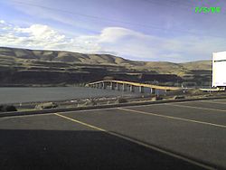 US97 Carried over the Columbia River by the Sam Hil Memorial Bridge, seen from Biggs Junction
Highways comprised
US 97 comprises the following highways (see Oregon highways and routes), from south to north:
- Part of The Dalles-California Highway No. 4; and
- The Sherman Highway No. 42.
US 97 Business in Klamath Falls, from south to north, comprises:
- Part of the Klamath Falls-Lakeview Highway No. 20 concurrent with Oregon Route 39;
- The Esplanade Spur, concurrent with Oregon Route 39; and
- Part of the Klamath Falls-Malin Highway No. 50.
US 97 Business in Bend runs from its intersection with the main highway at East 1st Street north of Bend, south on East 1st Street, Deschutes Place, and Wall Street to Newport Avenue, concurrent with U.S. 20 Business, then continues south on a Wall Street-Bond Street couplet and east on Franklin Avenue until it rejoins the main highway at East 3rd Street.
Major intersections
- Note: Mileposts are measured from north to south. They do not reflect actual mileage due to realignments.
County Location Milepoint
[5]# Destinations Notes Klamath 291.73 State line 282.87 Merrill, Malin Former Lower Klamath Highway 280.16 Miller Island Road (Midland Highway) Klamath Falls 277.47 South end of freeway 277.13 OR 66 / OR 140 – Lakeview, Medford276.74 Green Springs Drive Northbound exit only 275.06 
US 97 Bus. north – Klamath Falls City Center273.62 Oregon Avenue, Lakeshore Drive 272.79 
 US 97 Bus. south / OR 39 south – Klamath Falls, Reno, Oregon Institute of Technology, Winema National Forest Headquarters
No southbound entrance 272.56 North end of freeway Modoc Point 257.83 Modoc Point Road Former Modoc Point Highway Lobert Junction 251.94  OR 62 west – Fort Klamath, Crater Lake
249.08 Chiloquin, Sprague River (OR 422) 247.54 247  OR 422 – Chiloquin, Crater Lake
Interchange Mazama Junction 216.12 Sun Mountain Road Former OR 232 Diamond Lake Junction 213.09  OR 138 (North Umpqua Highway) – Diamond Lake, Roseburg, Medford
195.15 OR 58 west – Oakridge, EugeneInterchange Deschutes 169.68  OR 31 east – Silver Lake, Lakeview
153.08 Century Drive Interchange 151.30 Cottonwood Road Interchange 143.45 Baker Road, Knott Road Interchange Bend 141.01
US 97 Bus. north (Third Street) to US 20 east – Burns139.68 South end of freeway 139.17 139 Reed Market Road – Old Mill District 138.75 Truman Avenue Southbound exit and entrance; access to Wilson Avenue (former Century Drive Highway[6]) 138.24 138 Downtown Bend, Mount Bachelor 137.80 Hawthorne Avenue Southbound exit and entrance 137.53 Lafayette Avenue – State/County Offices Southbound exit and entrance 137.13 137 Revere Avenue – Downtown Bend 136.31 136 Butler Market Road No northbound exit 135.46 135B Empire Boulevard – State Offices No southbound exit 134.97 135A
US 20 east / US 97 Bus. south – Bend Business District, BurnsSouthbound exit and northbound entrance 134.97 135A US 20 west – Sisters, SalemNorthbound exit and southbound entrance 134.75 North end of freeway Deschutes Junction 130.35 Deschutes Market Road, Tumalo Road Interchange Redmond 123.60 124 Airport Way, Yew Avenue – Redmond Airport Interchange 121.50 OR 126 – Sisters, Eugene, Salem, Prineville, John Day118.52 O'Neil, Lone Pine (OR 370) Jefferson 105.73 Culver, Round Butte Dam (OR 361 north) 97.29 US 26 east – Prineville, Mitchell, John DaySouth end of US 26 overlap Madras 92.46 D Street (OR 361 south) – Metolius, The Cove Palisades State Park 92.08 US 26 west – PortlandNorth end of US 26 overlap Wasco 74.83 Antelope, John Day Fossil Beds, Fossil (OR 293) Shaniko Junction 67.17
68.66 US 197 – Maupin, The DallesShaniko 56.53  OR 218 – Antelope, Fossil
Sherman Grass Valley 28.36 Krusow Street (OR 216) – Sherars Bridge, Tygh Valley 10.34 Old Sherman Highway – Wasco Former US 97 north 8.82  OR 206 – Wasco, Condon, Fulton Canyon
Interchange 7.50 Wasco (Wasco-Heppner Highway) Former US 97 south Biggs 0.03 Deschutes State Park (Celilo-Wasco Highway) Biggs Junction -0.13 I-84 / US 30 – The Dalles, Rufus, Pendleton-0.43 Sam Hill Memorial Bridge over the Columbia River (state line) References
- ^ Google, Inc. Google Maps – U.S. Route 97 in Oregon (Map). Cartography by Google, Inc. http://maps.google.com/maps?f=d&hl=en&geocode=9182925122815604750,43.670320,-121.503800&time=&date=&ttype=&saddr=US-97+%4043.670320,+-121.503800&daddr=44.251778,-121.184521&mra=mi&mrsp=1,0&sz=15&sll=44.253714,-121.170273&sspn=0.014908,0.039568&ie=UTF8&z=15&om=0. Retrieved June 8, 2009.
- ^ Murphy Road project, others in Bend could cost city $40M | The Bulletin
- ^ Bend narrows options for Cooley fix - What’s the best fix for the Cooley/97 intersection? | The Bulletin
- ^ AASHO October 2008 meeting
- ^ Oregon Department of Transportation, Public Road Inventory (primarily the Digital Video Log). Retrieved March 2008.
- ^ "The Dalles-California Highway No. 4". Oregon Department of Transportation. http://www.oregon.gov/ODOT/TD/TDATA/rics/docs/Straightline_Charts/slchart_pdfs/Hwy004_2010.pdf.
- [1] KTVZ - WWII Veterans' designation for Hwy. 97]
U.S. Route 97Previous state:
CaliforniaOregon Next state:
WashingtonCategories:- U.S. Route 97
- U.S. Highways in Oregon
- Transportation in Deschutes County, Oregon
- Transportation in Klamath County, Oregon
- Transportation in Wasco County, Oregon
- Transportation in Jefferson County, Oregon
- Transportation in Sherman County, Oregon


Wikimedia Foundation. 2010.