- San Angelo Regional Airport
-
San Angelo Regional Airport
Mathis Field
IATA: SJT – ICAO: KSJT – FAA LID: SJT Summary Airport type Public Operator City of San Angelo Location San Angelo, Texas Elevation AMSL 1,919 ft / 584.9 m Coordinates 31°21′18″N 100°29′47″W / 31.355°N 100.49639°WCoordinates: 31°21′18″N 100°29′47″W / 31.355°N 100.49639°W Map Location within Texas
 SJT
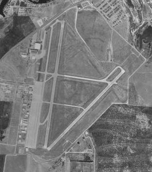
SJTRunways Direction Length Surface ft m 18/36 8,049 2,453 Asphalt 3/21 5,939 1,810 Asphalt 9/27 4,402 1,342 Asphalt - For the World War II use of the airport see San Angelo Army Airfield
San Angelo Regional Airport (IATA: SJT, ICAO: KSJT, FAA LID: SJT), also known as Mathis Field, is a public airport serving the city of San Angelo, in Tom Green County, Texas, USA. The airport covers 1,503 acres (608 ha) and has three runways. The airport also offers free parking.
Contents
History
The airport, originally named Carr Field, was built in 1941 by the United States Army Air Forces as a pilot training airfield. Activated on 1 June 1942, the airfield was assigned to the AAF Gulf Coast Training Center, with the Army Air Force Pilot School (Bomber and Specialized 2/4-Engine) activated (phase 3 pilot training). The school's mission was to train cadets to fly transports and bombers. It was transferred to the jurisdiction of the Army Corps of Engineers on 30 June 1946. Later the facility was disposed of by the War Assets Administration (WAA) and deeded to the local government.
The airport was later renamed in honor of local Jack W. Mathis, a bombardier who received the Medal of Honor.
Airlines and Destinations
Airlines Destinations American Eagle Dallas/Fort Worth References
- Airport Master Record (FAA Form 5010), also available as a printable form (PDF)
- San Angelo Regional Airport / Mathis Field (official web site)
External links
- Resources for this airport:
- AirNav airport information for KSJT
- ASN accident history for SJT
- FlightAware airport information and live flight tracker
- NOAA/NWS latest weather observations
- SkyVector aeronautical chart for KSJT
- FAA current SJT delay information
Categories:- 1942 establishments
- Airports in Texas
- San Angelo, Texas
- Transportation in Tom Green County, Texas
- Buildings and structures in Tom Green County, Texas
- Texas airport stubs

Wikimedia Foundation. 2010.