- National Register of Historic Places listings in Ashland County, Wisconsin
-
Buildings, sites, districts, and objects in Ashland County listed on the National Register of Historic Places
-
- This National Park Service list is complete through NPS recent listings posted November 10, 2011.[1]
Current listings
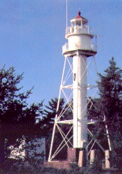
[2] Landmark name [3] Image Date listed Location City or town Summary 1 Apostle Islands Lighthouses 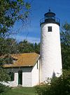
March 8, 1977 N and E of Bayfield on Michigan, raspberry, Outer, Sand and Devils Islands
46°59′38″N 90°36′06″W / 46.993889°N 90.601667°WBayfield 2 Ashland County Courthouse March 9, 1982 201 W. 2nd St.
46°35′28″N 90°53′07″W / 46.591111°N 90.885278°WAshland 3 Ashland Harbor Breakwater Light 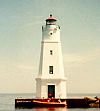
March 1, 2007 Breakwater's NW end in Chequamegon Bay, 2 mi. N of Bay City Ck. mouth
46°37′41″N 90°52′13″W / 46.628056°N 90.870278°WAshland 4 Bass Island Brownstone Company Quarry March 29, 1978 N of La Pointe on Basswood Island
46°49′56″N 90°45′20″W / 46.832222°N 90.755556°WLa Pointe 5 Beaser School July 17, 1980 612 Beaser Ave.
46°34′52″N 90°53′37″W / 46.581111°N 90.893611°WAshland 6 BIG BAY SLOOP shipwreck (sloop) January 14, 2009 Address Restricted La Pointe 7 Coole Park Manor June 1, 2005 351 Old Fort Rd.
46°45′55″N 90°47′00″W / 46.765278°N 90.783333°WLa Pointe 8 Copper Falls State Park 
December 16, 2005 WI 169, 1.8 mi. NE of Mellen
46°22′33″N 90°38′50″W / 46.375833°N 90.647222°WMorse 9 Ellis School July 17, 1980 310 Stuntz Ave.
46°35′39″N 90°52′21″W / 46.594167°N 90.8725°WAshland 10 Glidden State Bank March 29, 2006 216 First St.
46°08′15″N 90°34′28″W / 46.1375°N 90.574444°WJacobs 11 Hadland Fishing Camp August 18, 1977 N of La Pointe on Rocky Island
47°02′38″N 90°39′57″W / 47.043889°N 90.665833°WLa Pointe 12 La Pointe Indian Cemetery August 3, 1977 S. Old Main St.
46°46′20″N 90°46′55″W / 46.772222°N 90.781944°WLa Pointe 13 La Pointe Light Station 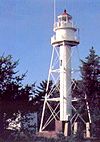
August 4, 1983 Long Island in Chequamagon Bay
46°46′43″N 90°47′21″W / 46.778611°N 90.789167°WBayfield 14 LUCERNE (Shipwreck) December 18, 1991 Address Restricted La Pointe (See/link to [1]) 15 Manitou Camp January 19, 1983 Manitou Island
46°57′20″N 90°40′35″W / 46.955556°N 90.676389°WApostle Islands National Lakeshore 16 Marina Site December 22, 1978 Address Restricted La Pointe 17 Marion Park Pavilion June 4, 1981 Marion Park
46°07′54″N 90°35′24″W / 46.131667°N 90.59°WGlidden 18 MARQUETTE (shipwreck) February 13, 2008 5 mi. E. of Michigan Island, Lake Superior
46°50′02″N 90°25′47″W / 46.833889°N 90.429722°WLa Pointe 19 Mellen City Hall September 20, 1979 Bennett and Main Sts.
46°19′38″N 90°39′35″W / 46.327222°N 90.659722°WAshland 20 Memorial Hall April 27, 1995 1511 Ellis Ave.
46°34′47″N 90°52′25″W / 46.579722°N 90.873611°WAshland 21 MOONLIGHT shipwreck October 1, 2008 Address Restricted La Pointe vicinity 22 Morty Site (47AS40) June 13, 1988 Address Restricted Bayfield 23 NOQUEBAY (Schooner-Barge) Shipwreck Site June 4, 1992 Address Restricted
46°55′45″N 90°32′39″W / 46.929167°N 90.544167°WLa Pointe (see/link to [2]) 24 Old Ashland Post Office January 21, 1974 601 West Second St.
46°35′20″N 90°53′22″W / 46.588889°N 90.889444°WAshland 25 P-Flat Site (47AS47) September 19, 1988 Address Restricted Bayfield 26 PRETORIA (schooner-barge) Shipwreck Site August 17, 1994 Address Restricted Bayfield 27 R. G. STEWART (Shipwreck) December 27, 1991 Address Restricted La Pointe 28 Rocky Island Historic District July 3, 2008 Rocky Island, Apostle Islands National Lakeshore La Pointe vicinity 29 Security Savings Bank December 27, 1974 212-214 W. 2nd St.
46°35′26″N 90°53′05″W / 46.590556°N 90.884722°WAshland 30 Soo Line Depot November 3, 1988 Third Ave. W, at Fourth St.
46°35′20″N 90°53′02″W / 46.588889°N 90.883889°WAshland 31 T. H. Camp (shipwreck) September 15, 2004 Address Restricted La Pointe 32 Trout Point Logging Camp December 16, 1988 Address Restricted Bayfield 33 Union Depot March 23, 1979 417 Chapple Ave.
46°35′08″N 90°53′20″W / 46.585556°N 90.888889°WAshland 34 Wakefield Hall May 4, 1995 1409 Ellis Ave.
46°34′50″N 90°52′25″W / 46.580556°N 90.873611°WAshland 35 West Second Street Historic District February 2, 1984 W. 2nd St. from Ellis Ave. to 6th Ave.
46°35′24″N 90°53′10″W / 46.59°N 90.886111°WAshland 36 Wheeler Hall, Northland College September 13, 1977 1411 Ellis Ave.
46°34′50″N 90°52′27″W / 46.580556°N 90.874167°WAshland 37 Wilmarth School July 17, 1980 913 3rd Ave. W.
46°35′01″N 90°52′48″W / 46.583611°N 90.88°WAshland 38 Winston-Cadotte Site December 16, 2005 Address Restricted La Pointe Formerly listed
[2] Landmark name Image Date listed Location City or town Summary 1 Ashland Middle School May 12, 2009[4] 1000 Ellis Ave. Ashland Listed July 17, 1980[3] See also
- List of Registered Historic Places in Wisconsin
References
- ^ "National Register of Historic Places: Weekly List Actions". National Park Service, United States Department of the Interior. Retrieved on November 10, 2011.
- ^ a b Numbers represent an ordering by significant words. Various colorings, defined here, differentiate National Historic Landmark sites and National Register of Historic Places Districts from other NRHP buildings, structures, sites or objects.
- ^ a b "National Register Information System". National Register of Historic Places. National Park Service. . http://nrhp.focus.nps.gov/natreg/docs/All_Data.html.
- ^ "Weekly List". National Park Service. May 22, 2009. http://www.nps.gov/history/nr/listings/20090522.HTM. Retrieved May 24, 2009.
U.S. National Register of Historic Places Topics Lists by states Alabama • Alaska • Arizona • Arkansas • California • Colorado • Connecticut • Delaware • Florida • Georgia • Hawaii • Idaho • Illinois • Indiana • Iowa • Kansas • Kentucky • Louisiana • Maine • Maryland • Massachusetts • Michigan • Minnesota • Mississippi • Missouri • Montana • Nebraska • Nevada • New Hampshire • New Jersey • New Mexico • New York • North Carolina • North Dakota • Ohio • Oklahoma • Oregon • Pennsylvania • Rhode Island • South Carolina • South Dakota • Tennessee • Texas • Utah • Vermont • Virginia • Washington • West Virginia • Wisconsin • WyomingLists by territories Lists by associated states Other Municipalities and communities of Ashland County, Wisconsin Cities 
Village Towns Agenda | Ashland | Chippewa | Gingles | Gordon | Jacobs | La Pointe | Marengo | Morse | Peeksville | Sanborn | Shanagolden | White River
CDPs Birch Hill | Clam Lake | Diaperville | Franks Field | Glidden | Marengo | New Odanah | Odanah
Unincorporated
communitiesBallou | Birch | High Bridge | La Pointe | Minersville | Morse | North York | Sanborn
Footnotes ‡This populated place also has portions in an adjacent county or counties
Categories:- Ashland County, Wisconsin
- Lists of historic places in Wisconsin
-


Wikimedia Foundation. 2010.