- Texas State Highway 8
Infobox TX State Highway
type=State
route=8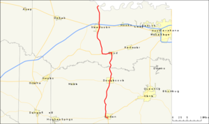
length_mi=41.4
length_ref=TxDOT|SH|8|accessdate=2008-03-15]
length_round=1
formed=1917
dir1=South
dir2=North
from=jct|state=TX|TX|155 in Linden
junction=jct|state=TX|US|67 in Corley
jct|state=TX|US|82 in New Boston
jct|state=TX|I|30 in New Boston
to=jct|state=AR|AR|41
previous_route=7
previous_type=State
next_route=9
next_type=State|State Highway 8 or SH 8 is a north-south state highway that runs from the Red River, the
Texas -Arkansas boundary, north of New Boston to SH 155 at Linden.History
.
In
1922 SH 8 was rerouted from Buna to Beaumont and into Port Arthur via present day US 96. The Buna-Orange section became State Highway 62 by 1932.In
1926 , US 59 and 96 were overlaid over pieces of SH 8. While the entirety of the SH 8 maintained its number, by1939 most of SH 8 was cancelled, leaving only the Arkansas-Corley segment to the old highway. In1947 a small segment was reassigned back to SH 8 from US 59 from Corley to Linden when US 59 was rerouted further east.SH 8 was rerouted around the western side of Linden in 1964, with the old route becoming FM 125.
in 1919. By 1933, it had been renumbered as SH 21 and SH 87.
Route description
SH 8 begins on the south side of the city on Linden at an intersection with SH 155, less than a quarter of a mile west of its intersection with US Route 59. The highway travels north through northern Cass County, crossing over Wright Patman Lake into Bowie County. The highway briefly turns west with US Route 67 when they intersect in Maud. The route then turns back north, running along the western edge of the Red River Army Depot. It then passes through the city of New Boston and intersects Interstate 30. The route then continues north, crossing the Red River, and the Arkansas State Line, where it becomes Arkansas Highway 41.
Junction list
References

Wikimedia Foundation. 2010.