- Olmsted Locks and Dam
-
Olmsted Locks and Dam 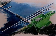
Rendering of Olmsted Locks and Dam.Location  Pulaski County, Illinois / Ballard County, Kentucky USA
Coordinates 37°11′02″N 89°03′49″W / 37.1838°N 89.0635°WCoordinates: 37°11′02″N 89°03′49″W / 37.1838°N 89.0635°W Construction began December 1995 Opening date 2016 (Scheduled) Dam and spillways Height 62 feet (19 m) Length 2,596 feet (791 m) Impounds Ohio River The Olmsted Locks and Dam is a concrete dam and locks project currently under construction on the Ohio River at river mile 964.4. It is located near Olmsted, Illinois. The lock chambers will be 110 feet (34 m) wide and 1,200 feet (370 m) long.[1]
Construction Stages Timeline Nov. 1992 - June 1994 Build access road and resident engineers office. May 1993 - Dec. 1995 Construction of lock cofferdam on the Illinois shore. Cost approximately $58 million. 1994 - Dec. 1995 Build prototype at Smithland Locks and Dam to select materials. Dec. 1995 - Mar. 2002 Construction of lock chambers. Cost $271.5 million Sept. 2001 - July 2005 Install bulkheads. Cost $24.2 million. June 2001 - Oct. 2002 Relocate Olmsted boat ramp downstream. Scheduled Operational buildings and service mound. Jan. 2004 - 2014 Construction of tainter gates and navigable pass dam. Scheduled Demolition of Locks and Dams 52 and 53. Source: US Army Corps of Engineers website[2]
 Aerial shot of the Olmsted site in August 2008
See also
References
Categories:- Buildings and structures in Ballard County, Kentucky
- Buildings and structures in Pulaski County, Illinois
- Ohio River
- Dams in Illinois
- Dams in Kentucky
- Locks of the United States
- Buildings and structures under construction in the United States


Wikimedia Foundation. 2010.