Clashnessie

Clashnessie
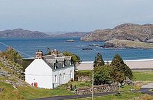
Clashnessie Bay and de-crofted house

Clashnessie (Scottish Gaelic: Clais an Easaidh) is a small crofting community on the North-West coast of Scotland; specifically in the Assynt area of Sutherland.

The township (the old Scottish term for a crofting village) is scattered around the sandy beach of Clashnessie Bay and derives its name from the Gaelic clais an easaidh, meaning glen (clais) of the (an) waterfall (easaidh), referring to the waterfall at the head of the shallow glen in which most of the houses stand. Although 100 miles (160 km) north of Inverness, the village's micro-climate is generally mild, due to the closeness to the Atlantic Ocean Gulf Stream.

Today Clashnessie has just nineteen houses distributed widely over roughly a square mile area. Ten of these houses are original nineteenth-century crofters' cottages, or rebuilds, while the remaining nine are of more recent construction in a variety of styles. In the landscape around them are a number of the ruined traces of earlier dwellings and barns, the unmortared blackhouses of the crofters who were first cleared to the coast from more arable homelands in the interior. By the 1960s the resident population had fallen to around a dozen people, although within living memory Clashnessie had an inn, a post office, and a shop. The ruins of the community mill, of the kind with a horizontally-mounted water-wheel, can still be seen at the side of the burn which runs down from the waterfall. The traces of the old poorhouse can still also be found on the roadside. Today the community is truly international. Although many houses have been decrofted, there has been some successful revival of traditional crofting too, with Highland cattle joining the traditional Cheviot sheep on the community's common grazing. Access to broadband has made cyber-crofting possible, which also adds to the long-term viability of the township.

External links

Coordinates: 58°13′19″N 5°18′55″W / 58.22194°N 5.31515°W / 58.22194; -5.31515


Wikimedia Foundation. 2010.

Игры ⚽ Нужно сделать НИР?

Look at other dictionaries:

  • Clashnessie —    CLASHNESSIE, a village, in the late quoad sacra parish of Stoer, parish of Assynt, county Sutherland, 13 miles (N. W. by W.) from Assynt; containing 194 inhabitants. This place is seated at the head of a small bay bearing its own name, and on… …   A Topographical dictionary of Scotland

  • Assynt — Ardvreck Castle am Loch Assynt Der Assynt ist ein Bezirk im Westen der Grafschaft Sutherland. Seit 1993 ist der größte Teil des Gebiets im Besitz der Genossenschaft Assynt Crofter s Trust. Zu den touristischen Höhepunkten zählen Ardvreck Castle… …   Deutsch Wikipedia

  • Stoer, or Store —    STOER, or STORE, lately a quoad sacra parish, in the parish of Assynt, county of Sutherland, 19 miles (W. N. W.) from the village of Assynt; containing, with the village of Clashnessie and the island of Oldeney, 1478 inhabitants. This district …   A Topographical dictionary of Scotland

  • Lochinver — infobox UK place country = Scotland official name= Lochinver gaelic name= Loch an Inbhir population = os grid reference= latitude=58.15 longitude= 5.25 unitary scotland= Highland lieutenancy scotland= Sutherland constituency westminster=… …   Wikipedia

  • List of bays of the British Isles — This is a list of bays of the British Isles, geographically by island. They are listed by island, in clockwise order, from the stated starting point.BritainClockwise from the River Tweed:England from the River Tweed to the Bristol Channel*Budle… …   Wikipedia

  • Assynt — ( gd. Asainte ) is a parish in west Sutherland, Highland, Scotland ndash; north of Ullapool.It is famous for its landscape (Inverpolly Nature Reserve) and its remarkable mountains (Quinag, Canisp, Suilven, Cul Mòr, Stac Pollaidh, Ben More Assynt) …   Wikipedia

  • List of places in Highland — This article is a list of links for any town, village, hamlet and settlements, in the Highland council area in Scotland. The area encompassed by the Highland council is a slightly different area to that encompassed by the Scottish… …   Wikipedia

  • Lochinver — Koordinaten 58° 9′ N, 5° 15′ W …   Deutsch Wikipedia

  • Assynt — 58° 12′ 54″ N 5° 03′ 02″ W / 58.215, 5.0505 Assynt est une paroisse de …   Wikipédia en Français

Share the article and excerpts

Direct link
Do a right-click on the link above
and select “Copy Link”