- Inkerman
Infobox Settlement
settlement_type =
subdivision_type = Country
subdivision_name = UKR
subdivision_type1 =Territory
subdivision_name1 =Crimea
timezone=EET
utc_offset=+2
timezone_DST=EEST
utc_offset_DST=+3
official_name = Inkerman
native_name = Інкерман
Инкерман
İnkerman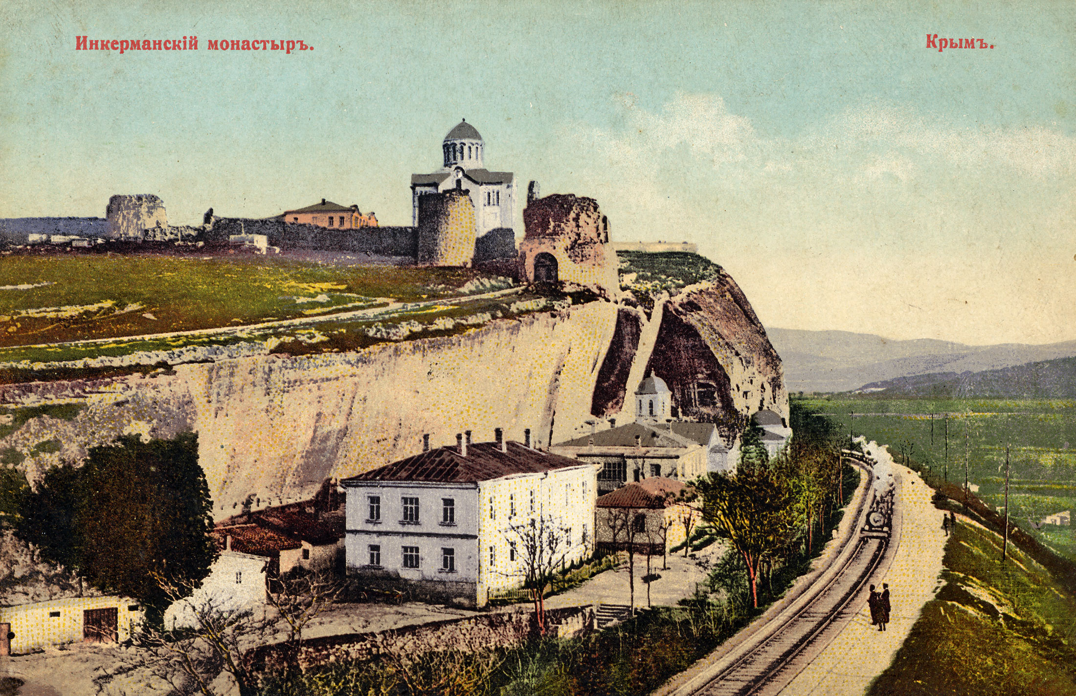
image_caption = Inkerman cave monastery around 1910
image_shield =Inkerman-arms.gif
subdivision_type2=Region
subdivision_name2 = Sevastopol
pushpin_
pushpin_label_position =
pushpin_map_caption =Location of Inkerman within the Crimea, Ukraine
pushpin_mapsize =
pushpin_map1 =
pushpin_label_position1 =
pushpin_map_caption1 =Location of Inkerman
pushpin_mapsize1 =
latd=44 |latm=36 |lats=0 |latNS=N
longd=33 |longm=36 |longs=0 |longEW=E
elevation_m = 50
area_total_km2 =
population_total = 10452
population_footnotes=
year = 2001
population_density_km2 =
postal_code_type=Postal code
postal_code = 99703 — 99709
area_code=+380-692
blank_info = Kalamita (until 1475), Belokamensk (1976 — 1991)
blank_name=Former names
website =Inkerman ( _uk. Інкерман, _ru. Инкерман, _cr. İnkerman) is a town in
Crimea ,Ukraine . It is situated 5 kilometres east ofSevastopol , at the mouth of the Chernaya River that flows into Sevastopol Inlet (aka the North Inlet). Administratively, Inkerman is subordinate to the municipality ofSevastopol which does not constitute part of theAutonomous Republic of Crimea .Inkerman is said to mean a "cave fortress" in Turkish. During the Soviet era (in 1976-1991) it was known as "Bilokamiansk" ( _uk. Білокам'янськ) or "Belokamensk" ( _ru. Белокаменск), which literally means "White Stone City", as a reference to soft white stone quarried in the area and commonly used for construction, but has since been returned its pre-Soviet name.
The area has been inhabited since ancient times. A
cave monastery of St. Clement was founded near Inkerman in the 8th century by Byzantine icon-worshippers fleeing persecution in their homeland. The monastery was destroyed during the Soviet era but has now been restored and brought back into use.Kalamita, a 6th century fortress expanded in the 14th century, now lying in ruins, was built at a strategic clifftop overlooking Inkerman and the Inlet. It was abandoned by a Turkish garrison in the 18th century after the raids by the Cossacks ended but a small settlement at the base of the cliff remained.
The town became the centre of worldwide attention in 1854 during the
Crimean War , when Inkerman was the scene of theBattle of Inkerman and theBattle of Chernaya River , both victorious for the French and the British troops.During the Soviet times, a large underground ammunition warehouse of the
Black Sea Fleet was situated under rocky cliffs in the Inkerman area. The storage was abandoned in 1970s after an explosion that damaged the facility but did not detonate all its stockpiles. However, no efforts to secure the site have been made until 1990s when local residents began salvagingexplosives for sale which led to a number of deaths. Ukrainian Army engineer corps started extracting and demolishing outdated ammunitions in 2000 under a special government program.Inkerman has since largely returned to its pre-war obscurity, serving as a suburb of Sevastopol linked to the downtown core by commuter ferries. One of the major Crimean wineries featuring the Inkerman label is located in the adjacent area. A popular hiking trail leading into Crimean Mountains begins just east of the town.
ee also
*
Little Inkerman External links
*en icon/ru icon/uk icon [http://www.sevastopol-adm.gov.ua/ Official Sevastopol city website]
*{ru icon [http://inkerman.balaklava.ws/ Inkerman]

Wikimedia Foundation. 2010.