- Dalhousie, New Brunswick
-
Dalhousie — Town — 
SealLocation of Dalhousie, New Brunswick

Coordinates: 48°03′49″N 66°22′12″W / 48.063611°N 66.37°W Country  Canada
Province  New Brunswick
County Restigouche Parish Dalhousie Founded 1827 Town Status 1905 Electoral Districts
Federal
Madawaska—RestigoucheProvincial Dalhousie-Restigouche East Government[1] - Type Dalhousie Town Council - Mayor Clem Tremblay - Councillors List of Members- Mark-Daniel Arsenau
- Anthony Letourneau
- Roland Dumont
- Sylvia Malley
- Robert Harquail
- Kenny Savoie
Area[2] - Land 14.51 km2 (5.6 sq mi) Population (2006)[2][3] - Total 3,676 - Density 253.4/km2 (656.3/sq mi) - Change 2001-06  6.4%
6.4%- Census Ranking 868 of 5,008 Time zone AST (UTC−4) - Summer (DST) ADT (UTC−3) Postal code(s) E8C Area code(s) 506 Access Routes
 Route 134
 Route 275
Dwellings 1,817 Median Income* $38,782 CDN Website www.dalhousienb.com *Median household income, 2005 (all households) Dalhousie (2006 population: 3,676) is a Canadian town located in Restigouche County, New Brunswick.[4]
Contents
History
 Dalhousie, N.B., looking toward Restigouche River, circa 1900
Dalhousie is the shire town of Restigouche County and dates European settlement to 1800. The Town of Dalhousie has been through some very distinct periods between its founding in 1825 and today. Prior to 1825, few showed much interest in the northern part of the province, but in that year the Great Miramichi Fire raged through central New Brunswick and into Maine, destroying the forests that were the mainstay of the province's economy. Lumbermen looked north to the great pine stands of the Nipisiguit and the Restigouche.[5]
Dalhousie, located at the mouth of the Restigouche, began to grow. Soon it was a booming town and became the Shiretown of the newly created Restigouche County. Lumber and fishing were the main interests, although agriculture was more important in the early days than it is today.[5]
 Lumber Sawmill Workers in Dalhousie, N.B., circa 1900
Dalhousie was the leading town of the area until the arrival of the railway following confederation. With steep hills at its back, the Intercolonial Railway (ICR) bypassed the town while its nearby rival, Campbellton, surged ahead. That would be the situation until the late 1920s, when Dalhousie was picked as the site of a giant paper mill. The International Paper Company built what was then one of the largest newsprint mills in the world and the town changed forever. From 1929 on, the mill would dominate life in Dalhousie.[5]
Parents of some of our older citizens would tell their children that, in some ways, it was a better town before the mill. Certainly the mill is one of the town's most imposing features. It occupies much of one side of the main street, blocking access to and even views of the shore. Dalhousie has been called "a waterfront town without a waterfront." The mill also meant that the town had a high average income. It brought a new and different kind of prosperity. Still, Dalhousie was in the situation of many one-industry towns – dependent on the success of that one main sector of its economy.[5] (For information concerning the 2008 mill closure, see Economy section)
The hilly town site was first laid out in 1826 with the first settlement established by Scottish settlers in 1827. It was named after the 9th Earl of Dalhousie, who was then the governor of both Upper Canada and Lower Canada. Some Acadians displaced in the Great Upheaval also settled in Dalhousie, and to this day there is a very close balance between anglophones and francophones. Many of the present residents can trace ancestry back to the original European settlers in the region. The Eel River Bar First Nation, adjacent to Dalhousie, is home to many Micmac natives, who were the original residents of the region.
Dalhousie was officially incorporated in 1905.
Geography
Dalhousie is the most northern point in New Brunswick, and thus is in the Maritime provinces. It is situated in the Restigouche River valley at the tongue of the river where it discharges into Chaleur Bay. The valley lies in a hilly region, part of the Appalachian mountain range, although the Dalhousie town site is situated on a hill side several decameters above sea level with some development to its south on a low ridge of approximately 260 metres elevation. The town is surrounded by salt and fresh water bodies, which are home to many species of wildlife, unique birds, and fish. The area is rich in natural resources.
Dalhousie faces Miguasha, Quebec on the Gaspé Peninsula to the north. The city of Campbellton lies 20 km upriver to the west and the city of Bathurst is approximately 80 km southeast along the shore of Chaleur Bay. There are no major centres south of Dalhousie as this is the undeveloped and heavily forested geographic centre of the province.
Demographics
Population trend[6]
Census Population Change (%) 2006 3,676 6.4%Adjustment 3,928 1.2%2001 3,975 11.7%1996 4,500 5.8%1991 4,775 N/A Mother tongue language (2006)[2]
Language Population Pct (%) French only 1,760 49.58% English only 1,715 48.31% Both English and French 30 0.84% Other languages 45 1.26% Economy
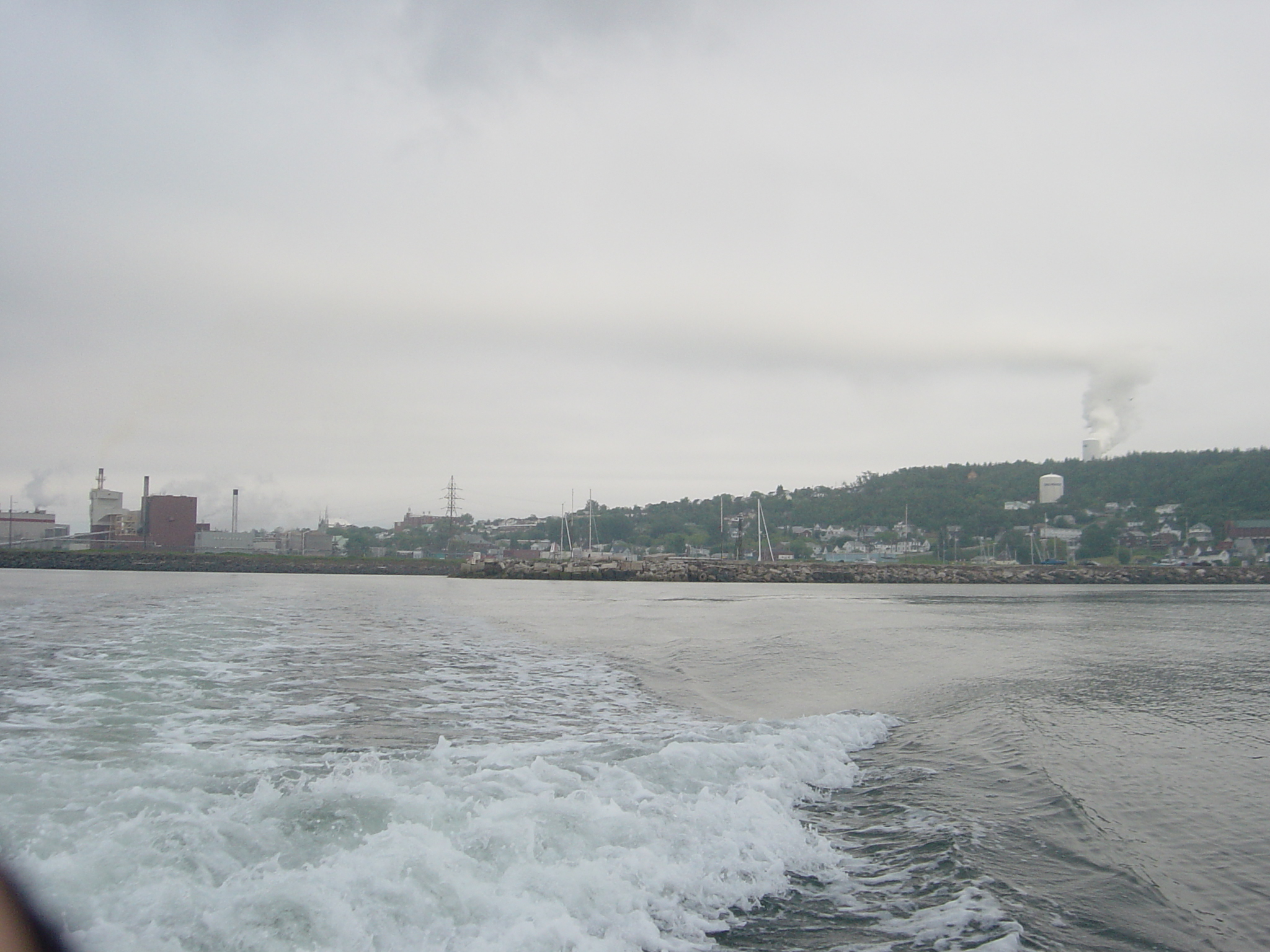
 Mills at Dalhousie
Until January 31, 2008, the economy was dominated by the forestry industry, namely a large pulp and paper mill spanning the waterfront along the Restigouche River. This mill was built to produce newsprint by the New Brunswick International Paper Co. in 1928 (a subsidiary of International Paper).
The mill underwent ownership changes in 1980, when Oji Paper Co. Ltd. and Mitsui & Co. of Japan purchased 33 per cent of the mill . They grouped it under the name Canadian International Paper and 1991, when it was purchased by Canadian Pacific Limited (who grouped it under their Canadian Pacific Forest Products subsidiary), and again in 1994 (when CPFP changed to become Avenor Inc.. In 1998 Bowater purchased the Dalhousie newsprint mill from Avenor who renamed the mill "Bowater Maritimes Inc.".
The 2007 merger of Bowater and Abitibi Consolidated resulted in the decision by the newly merged company to announce the closure of the Dalhousie newsprint mill on November 29, 2007. The mill, which produced 640 tonnes of newsprint per day for shipment by rail, truck and ship to domestic and international markets, was officially closed on January 31, 2008. Consequently the town of Dalhousie's economy is facing uncertainty during the post-industrial adjustment. Due to the closure of this mill, hundreds were left without jobs and were forced to move.
Following the closure of the pulp and paper mill, Pioneer Chemicals closed a processing plant on the western edge of the town. As a result of the closures of these industries, the New Brunswick East Coast Railway and its subsequent owner CN Rail announced that it was declaring the railway spur into the town surplus. Should a buyer of the line not come forward, the tracks will be scrapped and the right of way sold.
The town's only remaining industry is the Dalhousie Generating Station, a thermal power plant operated by NB Power.
Attractions
Tourism
Dalhousie is home to the Inch Arran Park , one of New Brunswick's highest-rated campgrounds.
Dalhousie Mountain offers stunning panoramic views of the entire region and the Gaspé coast.
With four very well defined seasons, Dalhousie is the perfect home - or destination - for the sports enthusiast. Water sports such as sailing and power boating are increasingly popular in the summer, as are skiing, snowmobiling, and ice fishing in the winter.
The popular Bon Ami festival in the summer serves as a homecoming for the community, where residents celebrate the town and its heritage.
The town is commonly referred to as a Papertown.
Transportation
The town benefits from its geography by having a deep sea port located adjacent to the pulp and paper mill.
It is also served by the New Brunswick East Coast Railway and is located on the Highway 11 arterial highway. Via Rail Canada provides passenger train service 6 days/week with stops at Charlo immediately east of the town and in Campbellton to the west.
The Charlo Airport is located several kilometres east of the town for private and charter service with scheduled air service available at the Bathurst Airport.
Education
Dalhousie has two elementary schools (Académie Notre Dame and L.E.Reinsborough), one middle school (Dalhousie Middle School), and two high schools (Dalhousie Regional High School and École Aux Quatre Vents).
Religion
Christianity is the dominant religion, with the Roman Catholic Church being the largest denomination. Protestant denominations include the Anglican Church of Canada, United Church of Canada, Presbyterian Church in Canada and several evangelical groups.
People
Some notable people that are from Dalhousie include:
- Guy Arseneault, teacher and politician
- Joseph Cunard Barberie, politician
- Joel Bernard, politician
- Gordie Dwyer, National Hockey League player
- Charles H. LaBillois, politician and merchant
See also
References
- ^ Government of New Brunswick website: Dalhousie
- ^ a b c 2006 Statistics Canada Community Profile: Dalhousie, New Brunswick
- ^ Statistics Canada Population and dwelling counts, for Canada and census subdivisions (municipalities), 2006 and 2001 censuses - 100% data
- ^ New Brunswick Provincial Archives - Dalhousie
- ^ a b c d http://www.museevirtuel.ca/pm_v2.php?id=exhibit_home&fl=0&lg=Francais&ex=00000587&pg=0
- ^ Statistics Canada: 1996, 2001, 2006 census
External links
- the DRHS school website
- the AQV school website
- the Town of Dalhousie website
- Downtown Dalhousie
- National 3 on 3 Hockey Championship

Restigouche River McNeish 
Chaleur Bay  Dalhousie

Eel River Crossing Eel River 3 Categories:- Communities in Restigouche County, New Brunswick
- Towns in New Brunswick
- Populated coastal places in Canada


Wikimedia Foundation. 2010.