- Imst (district)
Infobox Austrian district
subject_name = Bezirk Imst
region_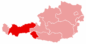
district_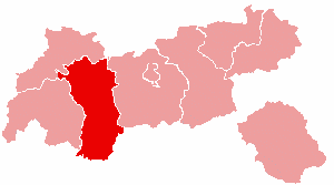
region = Tyrol
population = 52,658 (2001)
prefix = ?
area = 1724.8
car_plate = IM
nuts_code = ?
municipalities = 24
image_location = Karte-tirol-IM.pngThe Bezirk Imst is an administrative district ("
Bezirk ") in Tyrol,Austria . It borders the district Reutte in the north, as well asBavaria (Germany ), but only very shortly, the districtInnsbruck-Land in the east, Bolzano-Bozen (Italy ) in the south, and the district Landeck in the west.Area of the district is 1,724.82 km², with a population of 52,658 (
May 15 2001 ), and population density of 31 persons per km². Administrative center of the district isImst .Geography
The district comprises a part of the upper Inn valley with its tributary valleys
Ötztal ,Pitztal andGurgltal , and theMieminger Plateau . The area is dominated by high alpine mountains, mountain ranges include theStubai Alps ,Ötztal Alps , andMieminger Mountains .Historical populations
1869 |23079
1880 |22621
1890 |21387
1900 |20957
1910 |21536
1923 |21842
1934 |24210
1939 |25426
1951 |29954
1961 |33174
1971 |38326
1981 |42358
1991 |46833
2001 |52658
footnote= Source: [http://www.statistik.at/web_de/statistiken/bevoelkerung/volkszaehlungen/bevoelkerungsstand/index.html Statistik Austria]Administrative divisions
The municipalities of the district:
*
Arzl im Pitztal
* Haiming
*Imst
*Imsterberg
*Jerzens
*Karres
*Karrösten
*Längenfeld
*Mieming
*Mils bei Imst
*Mötz
*Nassereith
*Obsteig
*Oetz
*Rietz
*Roppen
*Sankt Leonhard im Pitztal
*Sautens
* Silz
*Sölden
*Stams
*Tarrenz
*Umhausen
*Wenns
Wikimedia Foundation. 2010.