- Ogurja Ada
-
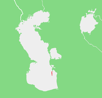 Location of Ogurja Ada.
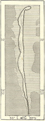 19th century Russian map of Ogurchinskiy Island
Ogurja Ada (sometimes also spelt "Ogurga") is the largest island in Turkmenistan and the longest in the Caspian Sea. Ogurja Island is also widely known by its Russian name Ogurchinskiy Island (Ostrov Ogurchinskiy).
Ogurja lies in the Southeastern coastal areas of the Caspian Sea. It is located 17 km SSW off the southern tip of the Cheleken Peninsula.
Ogurja Ada is very long and narrow. It runs from north to south, having a length of 47 km and a maximum width of 3 km it is made up of low sand dunes, mostly covered with grass and bushes.
The island has no permanent settlements owing to lack of fresh water. Between the 15th and the 17th century Ogurchinskiy had been a refuge for pirates and wayfarers and later it became a leper colony.[1] Administratively Ogurja Ada belongs to the Balkan Province (Balkan Welaýaty) of Turkmenistan.
Ecology
Caspian seals (Pusa caspica) and a number of different marine birds are common on the shores of this long island. Gazelles (jeirans) are also to be found on Ogurja Island. The gazelles are not endemic to the island, but were settled there as part of a natural reserve project during Soviet times when Turkmenistan was part of the USSR. Ogurja Ada is now part of the Hazar Nature Reserve of Turkmenistan.
References
External links
Ashuradeh • Baku Archipelago • Batkachnyy Island • Blinov Island • Bolshiye Peshnyye Islands • Bolshoy Setnoy Island • Boyuk Zira • Bulla Island • Chechen Island • Chikil • Chilov • Chistoy Banki • Durneva Island • Gil Island • Malyy Zhemchuzhnyy • Morskaya Chapura • Morskoy Biryuchek • Morskoy Ivan-Karaul • Nargin • Nizhniy Oseredok Island • Nordovyy • Ogurja Ada / Ogurchinskiy Island • Osushnoy • Pirallahı Island • Qara Su • Qum Island • Sedmoy • Spirkin Oseredok Island • Svinoy • Tyuleniy Archipelago • Tyuleniy Island • Verkhniy Oseredok Island • Vulf • Zenbil • Zhanbay Island • Zyudev IslandCategories:- Turkmenistan geography stubs
- Islands of the Caspian Sea
- Balkan Province
- Islands of Turkmenistan


Wikimedia Foundation. 2010.