Cortes, Surigao del Sur

Cortes, Surigao del Sur
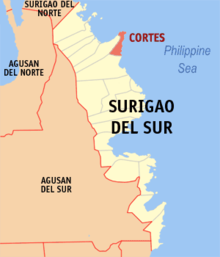
Map of Surigao del Sur showing the location of Cortes

Cortes is a 4th class municipality in the province of Surigao del Sur, Philippines. According to the 2000 Philippine census, it has a population of 14,825 people in 2,742 households.

Contents

Barangays

Cortes is politically subdivided into 13 barangays. In 1955, the sitios of Uba, Mabahin, Tag-anongan and Manlico were converted into barrios.[1]

  • Balibadon
  • Barobo
  • Burgos
  • Capandan
  • Mabahin
  • Madrelino
  • Manlico
  • Matho
  • Poblacion
  • Tag-Anongan
  • Tigao
  • Tuboran
  • Uba

Geography

It is located near the Pacific Ocean, surrounded by sea water. It has protected Marine Sanctuary located in barangay Balibadon, Capandan, Mabahin, Poblacion, Tigao and Uba. It is known in the province of Surigao, del, Sur for its rich source of sea foods in the area. You can find different kinds of fish, crabs and etc. The vast ocean under its territory is protected by the local government of Cortes. It has beautiful beaches with white sands. It also have water falls. It also have a bird sanctuary located in Burgos. It also has a wide area for agriculture. It has two season, rainy and sunny.

Economy

Agriculture is the major source of living in Cortes. It is known for its rich source of sea foods. Fishing is one source of living. However, there are limitations that been lay down by the local government to protect their sea against abuse. Farming is the second source of living.

References

External links

Coordinates: 9°14′N 126°10′E / 9.233°N 126.167°E / 9.233; 126.167


Wikimedia Foundation. 2010.

Игры ⚽ Поможем написать реферат

Look at other dictionaries:

  • Cortes (Surigao del Sur) — Municipality of Cortes Lage von Cortes in der Provinz Surigao del Sur Basisdaten Bezirk …   Deutsch Wikipedia

  • Surigao del Sur — Localisation de la province de Surigao del Sur (en rouge) dans les Philippines. Administration Pays …   Wikipédia en Français

  • Surigao del Sur — Lage der Provinz Surigao del Sur Surigao del Sur ist die 56. Provinz des Inselstaates der Philippinen. Sie befindet sich an der nordöstlichen Küste der Insel Mindanao und gehört politisch dem Regierungsbezirk Caraga (Region XIII) an. Der Sitz der …   Deutsch Wikipedia

  • Surigao del Sur — Infobox Philippine province name = Surigao del Sur sealfile = Ph seal surigao del sur.png region = Caraga (Region XIII) capital = Tandag City founded = pop2000 = 501,808 pop2000rank = 49th largest popden2000 = 110 popden2000rank = 15th lowest… …   Wikipedia

  • Madrid, Surigao del Sur — Map of Surigao del Sur showing the location of Madrid Madrid is a 4th class municipality in the province of Surigao del Sur, Philippines. Madrid was named after the capital city of Spain, Madrid. It has 14 barangay s and two comprising the… …   Wikipedia

  • Carmen (Surigao del Sur) — Municipality of Carmen Lage von Carmen in der Provinz Surigao del Sur Basisdaten Bezirk …   Deutsch Wikipedia

  • Madrid (Surigao del Sur) — Municipality of Madrid Lage von Madrid in der Provinz Surigao del Sur Basisdaten Bezirk …   Deutsch Wikipedia

  • Marihatag, Surigao del Sur — Map of Surigao del Sur showing the location of Marihatag Marihatag is a 4th class municipality in the province of Surigao del Sur, Philippines. According to the 2000 census, it has a population of 16,394 people in 2,857 households. The current… …   Wikipedia

  • San Agustin (Surigao del Sur) — Municipality of San Agustin Lage von San Agustin in der Provinz Surigao del Sur Basisdaten Bezirk …   Deutsch Wikipedia

  • San Miguel (Surigao del Sur) — Municipality of San Miguel Lage von San Miguel in der Provinz Surigao del Sur Basisdaten Bezirk …   Deutsch Wikipedia

Share the article and excerpts

Direct link
Do a right-click on the link above
and select “Copy Link”