- Jamberoo, New South Wales
Infobox Australian Place | type = town
name = Jamberoo
state = New South Wales
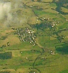
caption = Aerial photo from east
lga = Municipality of Kiama
postcode = 2533
est = 1833 - as Woodstock
pop = 942 (2001 Census)
elevation=
maxtemp =
mintemp =
rainfall =
stategov = Kiama
fedgov = Throsby
dist1 = 120
location1=Sydney
dist2 = 11
location2= KiamaJamberoo is a small picturesque village approx 11 km inland from Kiama on the South Coast of
New South Wales ,Australia in theMunicipality of Kiama . The population of the town is approx 942 while the population of the valley and town together makes about 1,200.It is well known for the
Jamberoo Action Park (previously Jamberoo Recreation Park), Jamberoo Hotel (Pub) and the localdairy farming community. TheAustralian Illawarra Shorthorn cattle breed originated in here. It is the birthplace of politicianJoseph Cullen .History
European history in the valley began in the early 1800s when the cedar-cutters moved through the rainforests gathering this valuable timber. Pioneer settlers followed in the early 1820s with William Davis receiving the first land grant in 1821, followed by John Ritchie and John Cullen shortly afterwards. cite book |title=Church of the Resurrection: Church of England: Jamberoo, 1867-1967 |publisher=Church of England Jamberoo |first=Elsie |last=Stewart |pages=2]
Michael Hyam was a property owner by the late 1830s and he laid out the private village of Jamberoo in 1841. The Main South Coast Road formed the northern boundary of his village and at the western end of the town he gave out lots for Protestant Churches. The Presbyterian church of St Stephen stands on the original lot. The Methodist church around the corner in Wyalla St is now the
Uniting Church and still hosts services, while the land given to the Church of England, nowAnglican Church of Australia has been sold off and theAnglican Church is located north of Hyam's Creek on Tate's Hill. The old Presbyterian, Anglican and Uniting cemeteries are still located on the original lots, although they have been closed to burials since at least the 1920s [cite book |title=Church of the Resurrection: Church of England: Jamberoo, 1867-1967 |publisher=Church of England Jamberoo |first=Elsie |last=Stewart |pages=?]A sign outside the only fuel station in Jamberoo proclaims the town as the birthplace of co-operative dairy production in Australia. The first co-operative butter factory in Australia was begun at Jamberoo in 1884 adjacent to the old Main South Coast Road (now Jamberoo Rd), 2 km from the Princes Highway and just west of Spring Creek and the monument marking the old toll gate. The location is better described as Kiama. An obelisk marks the spot. [cite web |url=http://walkabout.com.au/locations/NSWJamberoo.shtml |title=Walkabout travel guide: Jamberoo |publisher=
Sydney Morning Herald ]In time, there were other butter factories: Woodstock [Cite web |url=http://illawarraimages.wollongong.nsw.gov.au/illaweb/scripts/default.asp?Lib=/IllaIms |title=Woodstock Butter Mill |publisher=Wollongong City Council Image Library] and Wauchope [cite web |url=http://illawarraimages.wollongong.nsw.gov.au/illaweb/scripts/default.asp?Lib=/IllaIms |title=Woodstock Butter Mill |publisher=Wollongong City Council Image Library] which became the main factory in Factory Lane, just east of town. [cite web |url=http://illawarraimages.wollongong.nsw.gov.au/illaweb/scripts/default.asp?Lib=/IllaIms |title=Woodstock Butter Mill |publisher=Wollongong City Council Image Library]
Geography
Jamberoo sits at the western end of Minnamurra Swamp, known locally as The Swamp. The Minnamurra River flows from
Minnamurra Falls along the northern side of the swamp. Just east of the old butter factory on Factory Lane the river enters a man-made channel that keeps the river flowing on the northern side of the swamp; the original channel meandered through the broad eastern end of the swamp before crossing Swamp Road and running along the south side of the swamp. In times of high tide and high rainfall, the river resumes its old course closing Swamp Road.The valley of Jamberoo and the Minnamurra River is steep-sided and reasonably narrow. As a result, the town and valley is not subject to the extremes of weather that nearby
Albion Park is. This is a significant observation because the climate data for the district is recorded at Albion Park. Local research (unverified) from Jamberoo weather stations suggests that wind speeds in Jamberoo are approximately half that experienced at Albion Park, while rainfall varies significantly depending on the altitude and proximity to the steep valley sides. Air temperature is not as extreme as recorded for Albion Park. [Unpublished weather data from the Anglican Rectory, Jamberoo compared with Bureau of Meteorology data from Albion Park Regional Airport]Governance
At one stage of its history, Jamberoo was its own municipality. The present-day butcher shop in Allowrie St is the former Council Chamber while the bridge over Hyam's Creek that joins the northern and southern sides of the village was opened in 1937 by Mrs Fredericks, Mayor of Jamberoo. Jamberoo is presently a part of the Municipality of Kiama, State seat of Kiama and Federal seat of Throsby which, apart from Jamberoo, consists mostly of metropolitan areas of southern Wollongong and Shellharbour.
Demographics
Jamberoo has a 'self-perception' of being a town of older folk and dairy farmers. [Unpublished research, Jamberoo Anglican Church Vision Jamberoo document suite, Jamberoo Anglican Church] . However, research undertaken by the Anglican Church in Jamberoo reveals that the most significant age-group bands cover the age groups 40-49, followed closely by 10-19, in turn followed closely by 0-9. The "missing years" of 20-29 and 30-39 are significantly small by comparison, as are the 'golden years' from 50 and over. [Unpublished research, Jamberoo Anglican Church Vision, Jamberoo document suite]
Further research reveals that the "professional" is the major employment category for Jamberoo workers. Interestingly the vast majority of workers classed as "professional" are teachers and most of them are women. Their partners/husbands are very often trades people or supervisors in trade-related roles. Dairy farmers are a tiny minority as are retirees. [Unpublished research, Jamberoo Anglican Church Vision, Jamberoo document suite]
Education
Education in Jamberoo was first provided by the Church of England (now
Anglican ) on the site of the original grant of land from Michael Hyam. School commenced early in 1842 in a building partly funded by private subscription and government money. After a school teacher left in August 1873, there was talk of converting the school house into a Public School however this did not occur and it reopened in March 1874 with 40 students. [cite book |title=Church of the Resurrection: Church of England: Jamberoo, 1867-1967 |publisher=Church of England Jamberoo |first=Elsie |last=Stewart |page=10]The Public School came into operation in January 1878 which led to the closure of the denominational schools. [cite book |title=Church of the Resurrection: Church of England: Jamberoo, 1867-1967 |publisher=Church of England Jamberoo |first=Elsie |last=Stewart |page=11]
References
* [http://www.jamberooabbey.org.au Jamberoo Abbey]
* [http://www.jamberooanglican.com Jamberoo Anglican Church]
* [http://www.jamberoo-p.schools.nsw.edu.au Jamberoo Public School]
* [http://www.jamberoo.net Jamberoo Action Park]
* [http://www.jrooforum.com.au The JROO Forum]
* [http://www.jamberoopub.com Jamberoo Pub]
* [http://www.kiama.com.au/minnamurra_falls Minnamurra Rainforest and Falls]
Wikimedia Foundation. 2010.