- Churchman Brook Dam
-
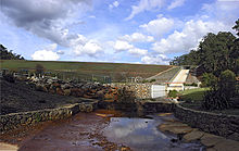 The dam wall and spillway
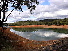 The reservoir.
Churchman Brook Dam, is an earthfill embankment dam situated approximately 30km south east of Perth, Western Australia in the City of Armadale. The reservoir is a water source for Perth.
It has a capacity of 2.24 million kilolitres for a catchment area of 16 square kilometres.[1]
Construction of the dam completed in 1929; the resident engineer was Sir Russell John Dumas.[2]
See also
References
External links
- Churchman Brook Catchment Area Drinking Water Source Protection Plan – Integrated Water Supply System, Department of Water, Government of Western Australia, Water Resource Protection Series Report No. WRP 66.
Coordinates: 32°9′0.4″S 116°4′40.5″E / 32.150111°S 116.077917°E
Categories:- Australian dam stubs
- Reservoirs and dams in Australia
- History of Western Australia
- Buildings and structures in Western Australia
- Water management in Western Australia


Wikimedia Foundation. 2010.